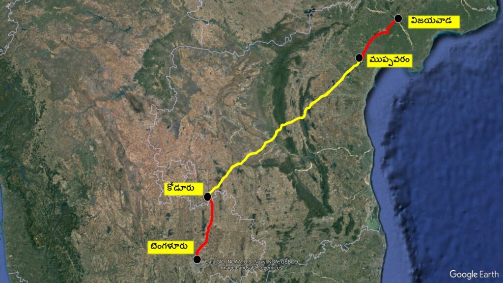
This corridor spans 531 km, passing through Andhra Pradesh and Karnataka. As part of Vijayawada-Benguluru corridor, a new 343 km expressway will be constructed in Andhra Pradesh.
This Corrdior also called as B-K-V corridor (Benguluru-kadapa-Vijayawada), has been divided into three parts:
From Vijayawada to Muppavaram in Bapatla district, and from Kodikonda in Sri Sathya Sai district to Bengaluru, existing highways will be utilized.
From Muppavaram to Kodikonda, a new access-controlled greenfield expressway will be constructed, essentially a new highway. This expressway has been designated as NH544G
- This expressway will pass through the districts of Bapatla, Prakasam, SPSR Nellore, YSR Kadapa, and Sri Sathya Sai. A video has been created to show the exact route map of the regions it will cover. Please watch the video for more details, friends.
The 6-lane expressway will have 13 interchanges across various locations to allow vehicles to enter and exit. These are called interchanges.
Packages:
This expressway is divided into 14 packages for ease of construction
Package | Length & chainage | Contractor |
1. Koduru to Vanavolu | 24.3 kms (Ch: 0.00 to 24.3km) | Dilip Buildcon |
2. Vanavolu to Vankarakunta | 21.4 kms (Ch: 24.3 to 45.7 km) | Raj Path Infracon |
3. Vankarakunta to Odulapalle | 26.3 kms (Ch: 45.7 to 72.0 km) | Raj Path Infracon |
4. Odulapalle to Nallacheruvu palli | 24.3 kms (Ch: 72.0 to 96.3 km) | Dilip Buildcon |
5. Nallacheruvu palli to Yerragudipadu | 32.7 kms (Ch: 96.3 to 129.0 km) | MEIL |
6. Yerragudipadu to Audireddipalle | 31 kms (Ch: 129.0 to 160.0 km) | MEIL |
7. Audireddipalle to Mallapalle | 16 kms (Ch: 160.0 to 176.0 km) | Dilip Buildcon |
8. Mallapalle to Kavulakuntla | 20 kms (Ch: 176.0 to 196.0 km) | MEIL |
9. Kavulakuntla to Narayanmpeta | 7.5 kms (Ch: 196.0 to 203.5 km) | Max Infra (I) Limited – Bekem Infra Projects Pvt. Ltd. (Consortium) |
10. Narayanmpeta to Chandrasekharpuram | 24.5 kms (Ch: 203.5 to 228.0 km) | MEIL |
11. Chandrasekharapuram to Polavaram | 32 kms (Ch: 228.0 to 260.0 km) | MEIL |
12. Polavaram to Marripudi | 25.5 kms (Ch: 260.0 to 285.5 km) | MEIL |
13. Marripudi to Somavarappadu | 29.1 kms (Ch: 285.5 to 314.6 km) | KNR Constructions |
14. Somavarappadu to Muppavaram | 28.64 kms(Ch: 314.6 to 343.24 km) | MEIL |
This expressway will reduce the Vijayawada-Bengaluru distance by 120 km and the
travel time by 4.5 hours
Over all details:
NH544G
No.of Lanes:6
Right of way: 90m
Entry/Exit Points (Interchanges): 13 nos
Vehicular Restrictions: No Two-wheelers or autos allowed
Service roads: Not available
Project cost: 20,000Cr